At least five individuals lost their lives Thursday in the San Antonio region as a result of flash floods caused by Texas’s unrelenting rain, which washed away cars and brought on fresh rounds of intense downpour.
San Antonio Police reported that shortly after 4 a.m. local time, first responders were dispatched to look into complaints of cars trapped in high water around the Loop 410 and Perrin Beitel regions.
At least two others were still missing in addition to the five dead, according to the San Antonio Fire Department.
According to San Antonio Police Chief William McManus, 13 cars were submerged in floodwaters, and investigators are trying to find out where anyone who might have fled the area is.
Additionally, first responders are attempting to recover the lost vehicles after other vehicles were reported to have been washed away.
almost the course of the last two days, San Antonio received around 6.67 inches of rain, with almost 6 inches pouring in the last day alone. This nearly doubles the city’s previous daily record of 3.26 inches established in 1973, making Thursday the wettest June day on record in San Antonio.
Additionally, since records began in July 1885, this is the eighth-wettest day overall in San Antonio.
Within 30 minutes, the New Braunfels region northwest of San Antonio received more than 3 inches of rain. A video taken near Santo, Texas, shows that the heavy rain caused major flooding.
First responders were seen in another video saving residents from Panama Road flooding. According to officials, there were reports of water up to four feet in some places, while “water flowing swiftly in most areas.”
Approximately 20 high-water rescues were handled by the San Antonio Fire Department, and flooding forced the closure of numerous highways.
In addition to numerous more in Comal and Hays counties, the National Weather Service reported that 40 low-water crossings were closed in Bexar County alone.
Furthermore, more than 41,000 cubic feet of water per second flowed down Leon Creek at Loop 410 near Leon Valley in the San Antonio area, which surged a dramatic 13 feet in two hours.
Because of the persistent severe weather and flash flooding in the area, Matagorda County declared a disaster on Thursday.
The disaster declaration now gives officials the authority to take the required steps to lessen the storm’s effects and guarantee citizens’ safety, according to the Matagorda County Emergency Operation Centre.
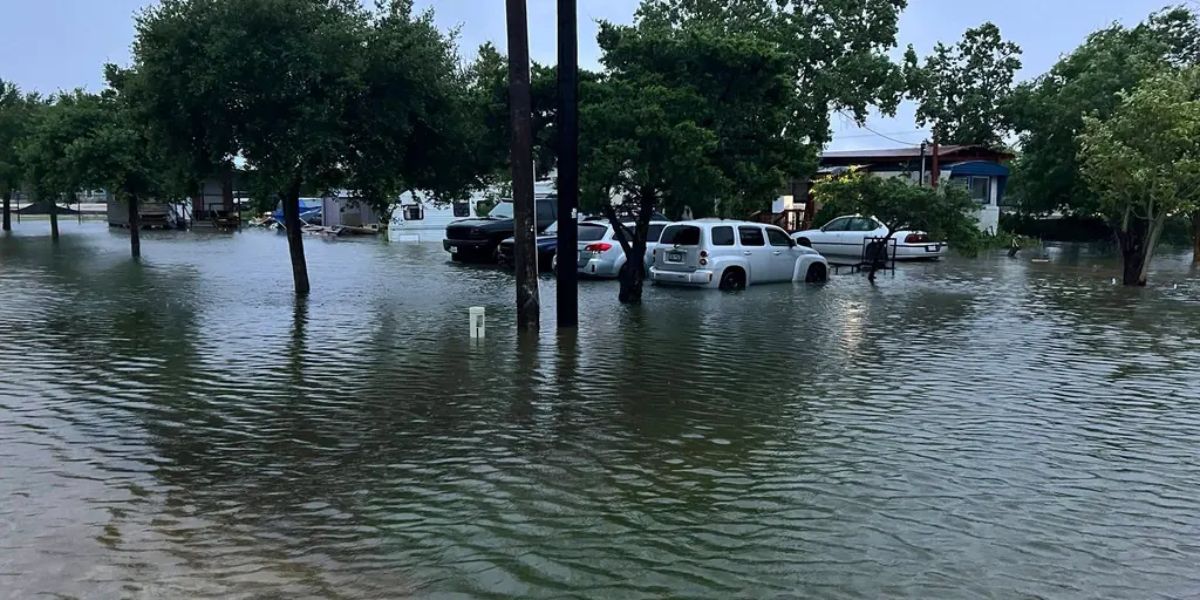
Images circulated from Matagorda County demonstrated the severity of the situation on Thursday morning. As water fills the area’s roadways and green spaces, floodwaters can be seen encroaching dangerously near homes.
Read Also: Summer Weather Continues Through Friday Before Rainy Weekend Ahead
The flooding in Victoria had prompted locals to stay indoors for their own safety.
Officials posted on Facebook that “no shelter-in-place order has been issued by the Victoria Office of Emergency Management.” “However, due to current weather and road conditions, residents are advised to stay home for their safety.”
There have also been reports of flooding in Houston.
According to the Houston/Galveston National Weather Service, these storms were powerful enough to produce two tornadoes in Wharton County, Texas, at around three in the morning, in addition to the flooding rain.
Just after 3 a.m., a tornado with winds of 100 mph struck behind some apartments northeast of Wharton, causing damage to numerous residences. According to the NWS’s first surveys, the damage was consistent with an EF-1 on the Enhanced Fujita Scale.
East of Burr, another tornado with an EF-0 preliminary classification made landfall and damaged trees along County Road 117.
The hazard is being exacerbated by a wet environment, with moisture levels much above normal for early June. Severe thunderstorm development is facilitated by strong instability and an abundance of storm energy.
Storms that form will be slow-moving due to the atmosphere’s continued mild winds, which might result in heavy rainfall and an increased risk of flooding.