Severe thunderstorms that brought hail, damaging winds, and localised flooding to South Florida on Friday may be an early warning sign of the state’s impending rainy season.
Significant damage was caused in a number of locations by the storms, which formed with the reinforcement of an old frontal boundary.
Trees and power lines were reported down in Broward County, and the gusty winds tossed at least one plane at the North Perry Airport in Pembroke Pines.
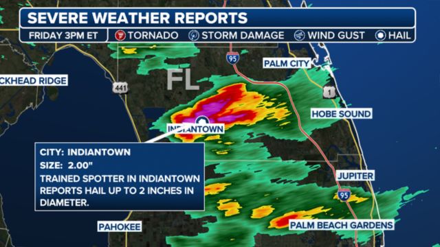
There have only been a few dozen instances of lime-sized hail falling on the Treasure Coast since the 1950s.
The damage was typical of gusty winds from a downburst, according to the National Weather Service, although some locals thought a tornado had made landfall.
Rapid columns of descending air, known as downbursts, can produce wind speeds of up to 100 mph and spread outward when they strike the ground.
These phenomena fall into one of two categories: microbursts or macrobursts, depending on their size and duration.
Larger areas are affected by macrobursts, which have slightly less concentrated winds than microbursts, which are smaller and more intense.
No damage was reported, but thunderstorm activity in the Florida Keys further south produced funnel clouds and waterspouts.
The storms’ timing coincides with the start of Florida’s rainy season, which normally lasts from mid- to late-May through September.
High temperatures, abundant moisture, and convergent sea breezes are the main drivers of seasonal activity, and they are frequently enough to start powerful to severe storms.
Don’t Miss:
- Tri-State Begins to Dry Out, but Cooler Weather Lingers for Memorial Day
- Florida Woman Accused of Assaulting 72-Year-Old Man Wearing MAGA Hat
- Above-Average Hurricane Season Forecasted Amid Warming Oceans
Global climate patterns like El Niño and La Niña can affect the length and severity of the rainy season.
While La Niña tends to hasten the onset of daily thunderstorms and increase rainfall, El Niño years may cause Florida’s wet season to be delayed and less intense.
The El Niño–Southern Oscillation, or ENSO, is currently in a neutral phase with hints of a La Niña stage, according to observations.
Because of this, Florida is expected to experience average to above-average rainfall for a large portion of the summer.
For drought-stricken areas of the state, especially those south of the Interstate 4 corridor, the forecast is welcome news.
Consistent rainfall over the next few weeks could start to mitigate the significant deficits, even though drought conditions are still present.
Historically, more severe thunderstorms with frequent lightning, destructive winds, and sporadic large hail have been observed during the first half of the rainy season.
With fewer reports of damage, the second half frequently yields the highest rainfall totals.
By late September, Florida’s rainy season usually comes to an end, and attention turns to tropical systems and, eventually, cold fronts that move in from the north and west.
| Location | Start Date |
| Miami | May 15 |
| Tampa | May 25 |
| Melbourne | May 28 |
| Orlando | May 27 |
| Jacksonville | Late May – Early June |
| Tallahassee | June 1 |