Kansas City is set to enjoy dry and mild conditions on Saturday; however, the National Weather Service has issued a warning about a potent storm system that may unleash severe weather, such as large hail, damaging winds, and tornadoes, as the workweek begins.
Expect mostly cloudy skies with temperatures hovering around 65 degrees in the metro area on Saturday, slightly below the seasonal average of 68 degrees.
A strong high-pressure system positioned over Minnesota is expected to move eastward during the day, ultimately settling over the western Great Lakes region by evening, according to the weather service’s forecast discussion.
Expect a rise in the likelihood of showers and thunderstorms Saturday night, particularly south of Interstate 70, with this pattern persisting into Sunday morning. There are no indications of any extreme weather conditions on the horizon.
Sunday will see temperatures reaching the low 70s. The weather service reports a 50% likelihood of rain showers and thunderstorms developing in the afternoon.
The weather service indicated that attention will turn to the possibility of severe storms on Monday evening and into the night.
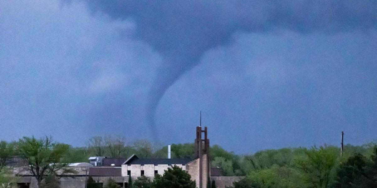
The weather service indicated that should storms form on Monday afternoon or evening, there is an increased chance they could turn severe. The conditions are likely to support the development of severe storms featuring significant hail, destructive winds, and potential tornadoes.
Supercells are formidable rotating storms characterized by towering cloud formations with distinctive anvil-shaped tops, known for their potential to generate significant hail, destructive winds, and tornadoes. In optimal environmental conditions, supercell thunderstorms have the potential to persist for several hours.
The weather service indicated that there is a degree of unpredictability concerning the timing and location of potential storm developments.
The unpredictability arises from the absence of a robust weather front to facilitate storm development and ambiguous wind patterns that influence storm structure, according to the weather service. A cold front is set to arrive later in the area, but it won’t coincide with peak heating and maximum instability, potentially affecting the strength and timing of storms.
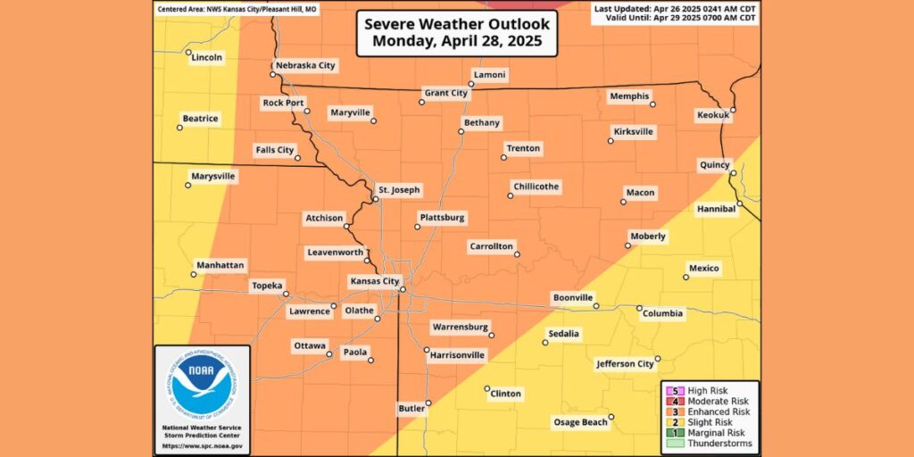
Severe weather outbreaks may occur in parts of the Midwest and Upper Midwest, according to the Storm Prediction Center of the National Weather Service.
Residents of Kansas City, Overland Park, Omaha, Minneapolis, and Madison, Wisconsin, should prepare for heightened severe weather conditions, classified as level three on the Storm Prediction Center’s five-point scale.
St. Paul, Des Moines, Cedar Rapids, Iowa, Rochester, Minnesota, and Bloomington, Minnesota, face a moderate risk, positioned at the fourth tier on the five-point scale.
Afternoon temperatures are projected to reach the low 80s.
As a cold front approaches the region, additional storms are anticipated by Monday night; however, the weather service indicates a reduced likelihood of severe weather conditions. Severe weather is anticipated to form with the advancing cold front, primarily posing risks of destructive winds and significant hail.
A cold front is set to sweep through the region overnight Monday into Tuesday morning, but it will likely stall just south of the area, resulting in a dynamic weather pattern that will persist until the week’s end.
Expect a bright and sunny Tuesday, with temperatures reaching close to 70 degrees.
The weather service indicated that this front will serve as the center for more rounds of showers and storms. “Should the front position itself slightly to the south of the region, the highest likelihood for rainfall will also be confined to that southern area.”
The southern half of the Kansas City forecast area is expected to experience a notable chance of rain, ranging from 25-75%, from Wednesday into Thursday.
The weather service indicated that the likelihood of rain will diminish later in the week and into the weekend.